

Oz Report
topic: IGC (32 articles)
IGC signature bug fixed for 6030
One second recording rate
Bräuniger IQ Compeo+|Flytec 6030|IGC|software|vario
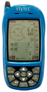
Joerg writes:
Please excuse the delay, this was supposed to be sent out earlier this year:
We just released new firmware for the Flytec 6030 (aka Bräuniger IQ Compeo+). This version fixes a bug that could cause the 1-second IGC file to be produced with an incorrect signature. The firmware can be downloaded from the Software support page for Flytec 6020 and 6030 (aka Bräuniger IQ Competino+ and Compeo+).
If you enjoy the fact that we are keeping your vario alive, donate us a cup of coffee. Thank you!
Pilots in the US can't send a donation using this link. I'm not exactly sure how to do this.
Discuss "IGC signature bug fixed for 6030" at the Oz Report forum link»
5 topics in this article: Bräuniger IQ Compeo+, Flytec 6030, IGC, software, vario
IGC of the future »
Coming up with a new file format
CIVL|IGC|Joerg Ewald|record|Stéphane Malbos
Stéphane Malbos writes:
FAI wishes to establish a New Technology Working Group (NTWG) for the purpose of defining modern standards for inflight electronic devices and for managing the data they generate.
Air Sport Commissions (ASC) today have requirements in areas such as
live scoring
anti-collision safety measures
search and rescue capabilities and
advanced flight data recording.
Adjuncts to these requirements are
how is the flight data collected?
how is the data transmitted?
what are the associated costs?
An example of current technology in this space is the highly successful ground-based tracking network, Open Glider Network (OGN) that is already available to all air sports.
In the future, Flight Recorders and their flight data files should exploit the latest technology so that they can be used in all FAI Air Sports in which Flight Recording could be a requirement.
New Technology Working Group - Members
Chairman of the WG: Dr. Angel Casado
Experts in the WG: Marc Andre, CIA Joerg Ewald, CIVL Richard Meredith-Hardy, CIMA Marc Ramsey, IGC
Support and advice: Visa-Matti Leinikki, FAI IT Manager
The Chairman of the working group may recruit additional members and advisors as needed.
Parties to be involved as may be necessary
a) Flight Recorder manufacturers
b) Event Organizers, users of FR
c) Providers of live tracking systems
d) Governmental Authorities related to airspace, NACs
e) Avionic related experts, manufacturers
f) Any other party that may be necessary
Mission
General principles
To be the reference in terms of electronic devices used in and across FAI Air Sport Commissions
To define FAI-standards for data collection and transmission devices.
To assure the use of the most appropriate measurements devices in competitions and performance flights, in particular to increase competition attractiveness, fairness and safety.
To find cost efficient solutions to technical challenges common to FAI disciplines such as tracking or logging.
Specific areas of concentration
Develop the next generation of FAI Flight Data Collection and Transmission:
1. Live tracking of aircraft during FAI sanctioned events Support for data communications protocols used by existing devices A new standard protocol, suitable for all air sports Standardized packaging of data for presentation
2. Second generation flight data recording A new extensible and modular format for flight data, suitable for all air sports Modern data transfer standards Integration with other avionics
3. Cloud-based support of FAI events Protocols for support of generic tracking devices and flight data recorders Centrally managed data integrity Integration with FAI database of International Badges and Records Integration with FAI Sporting License database FAI archiving of flight data
4 Transaction of business
Via email and/or Voice over IP services like Skype or Zoom. Specific workshop on this topic as part of the preparations of the FAI World Air Games 2022, scheduled to take place in the second half of 2019. Travel costs need to be pre-approved by FAI Secretary General.
Term
Develop such a system and propose it to the FAI General Conference 2021.
Discuss "IGC of the future" at the Oz Report forum link»
5 topics in this article: CIVL, IGC, Joerg Ewald, record, Stéphane Malbos
Prepping for the 2019 Green Swamp Sport Klassic
Checking out the tracks from 2018
Eduardo Fonseca|Airtribune|Green Swamp Sport Klassic 2019|IGC
Fonseca, Eduardo «eduardo.fonseca-1
In prep for the GSSK comp I built this map views with the IGC tracks for the top 5 pilots from the 2018 GSSK edition. Airtribune tracking/map features just doesn’t work for me at all, so I built my own (more portable than Google Earth and mobile-friendly). Hopefully Live Tracking some day. We'll have an approximation of live tracking for the GSSK. https://airtribune.com/2019-green-swamp-sport-klassic/info/details__info Discuss "Prepping for the 2019 Green Swamp Sport Klassic" at the Oz Report forum link» 4 topics in this article: Eduardo Fonseca, Airtribune, Green Swamp Sport Klassic 2019, IGC
The GPS 2019 Week Rollover
April 6, 2019
GPS|IGC
https://www.orolia.com/resources/blog/lisa-perdue/2018/gps-2019-week-rollover-what-you-need-know
There is a GPS week number rollover event on April 6/7 2019. After this date, some instruments might report the wrong date in an unpredictable manner. In competitions this spring it might be necessary to have a temporary measure to allow IGC files with the wrong date when a pilot's instrument is shown to have that behaviour. After all, it is not an issue with identifying which task is being attempted. The time and positions should remain correct. But any GPS chip designed over about ten years ago might fail. And it is possible that even newer instruments can be fitted with these older GPS chips.
Discuss "The GPS 2019 Week Rollover" at the Oz Report forum link»
Investigation into 2D fixes
Investigation into 2D fixes
Fixed the 17 year old code
Andrej Kolar|GPS|IGC
Andrej Kolar at Naviter Info <<info>> writes:
After re-examining our source code I agree with Wesley completely and we have changed the way fixes are stored in IGC files. The code is 17 years old and has never changed in this area.
Thanks, Wesley!
If you want to do more detailed testing I suggest you install the latest version on the Oudie and examine the NMEALog folder. The last 50 MB worth of raw NMEA sentences are always stored there.
3 topics in this article: Andrej Kolar, GPS, IGC
Converting IGC to Google Earth files
Converting IGC to Google Earth files
Color changes by altitude, for example
Google Earth|IGC|software
http://www.maddyhome.com/igc2kml
http://ozreport.com/data/15Qstraub.IGC.kmz.

Discuss "Converting IGC to Google Earth files" at the Oz Report forum link»
3 topics in this article: Google Earth, IGC, software
IGC track logs in Google Earth
IGC in GE
No need to convert to KML format
Google Earth|IGC|Ron Gleason
Ron Gleason «xcflying» writes:
This is a wonderful add-on to Google Earth to replay flights using IGC files. Due to higher resolution satellite images better than SeeYou.
I couldn't get this application to work for me. Ron writes:
It is an application that needs to be launched and it launches Google Earth. You then load the IGC file. I have heard that some folks had problems when they did not have .NET installed. Do not know if VISTA is an issue.
3 topics in this article: Google Earth, IGC, Ron Gleason
SeeYou updated to communicate correctly with the 5030 »
The latest version of SeeYou appears to communicate without errors
SeeYou
Flytec 5030|IGC|SeeYou|waypoints
SeeYou has been updated with a new Brauninger/Flytec communications module that apparently doesn't create the errors that were a problem before. You can download waypoints without a problem and upload flights that are valid for the on line contests.
This is a great improvement. I have had to use FlyChart (which is fine) to make sure that I could download valid track logs to IGC files from my Flytec 5030. Now I can do with with SeeYou.
I and Flytec have tested it and it appears to work fine.
Discuss "SeeYou updated to communicate correctly with the 5030" at the Oz Report forum link»
4 topics in this article: Flytec 5030, IGC, SeeYou, waypoints
IGC to KML translator
IGC
A new update
Google Earth|IGC|IGC2KML
Richard «rich.jen1» writes:
IGC2KML has another minor tweak and is now at version 2.3. Maximum height has now been added to the output. Download as usual from http://www.mycloudbase.com/google.
3 topics in this article: Google Earth, IGC, IGC2KML
IGC to Google Earth
IGC Converter
This is the best conversion program I've seen so far.
Google Earth|IGC|IGC2KML
Richard «rich.jen1» writes about his very cool IGC to KML file conversion program:
I've just fixed a small but annoying bug in IGC2KML, my program to convert and collate gps traces to a single google earth kml file. Version 1.1 can be found here: http://www.mycloudbase.com/google/index.htm
Also on this page is version 1.3 of AIS2KML which downloads NOTAMs and displays them in Google Earth.
Click on your flight and you get a lot of information about it in Google Earth.
3 topics in this article: Google Earth, IGC, IGC2KML
IGC to Google Earth
A local program or web based.
Google Earth|IGC|Harald Gergits|IGC2KML
Harald Gergits «hg» has a file converter on-line at http://www.hgs.at/igc4google/. I tested the latest version (1.2) and it works fine. It allows you to convert many IGC files at once.
Discuss "IGC to Google Earth" at the Oz Report forum link»
4 topics in this article: Google Earth, IGC, Harald Gergits, IGC2KML
Correction re IGC to KML converter
Fri, Aug 19 2005, 5:00:02 am EDT
Another author actually
Andreas Gehret|Google Earth|IGC|IGC2KML|Mario Mohl|software
Andreas Gehret «andreas» writes:
I don't want to be too German about this, but the IGC / Google Earth converter has not been developed by Mario Mohl but by Andreas Gehret. Www.e-ality.de, where the tool is available, is my blog. No need for a correction on your newsletter, just wanted to point that out.
6 topics in this article: Andreas Gehret, Google Earth, IGC, IGC2KML, Mario Mohl, software
Easily convert IGC to KML
Wed, Aug 17 2005, 5:00:02 pm EDT
Put your track logs in Google Earth
Google Earth
Google Earth|IGC|IGC2KML|Mario Mohl|software|track log
mario mohl «mariomohl» has created an on-line file converter that allows you to easily convert your IGC formatted track log to a file that can be read from Google Earth. He writes:
Just convert your regular .igc file to a perfectly functional .kml with the converter at http://www.e-ality.de/i2ge_e. Then download the resulting file to your computer.
Open the result in Google Earth and you'll even get correct altitude display as long as the "elevation exaggeration" in GE is set to 1. (tools---options---view).
6 topics in this article: Google Earth, IGC, IGC2KML, Mario Mohl, software, track log
Track logging software connected to Google Earth
The obvious connection.
CUP|G7ToWin|Google Earth|GPS|IGC|Ulf Arndt
Ulf Arndt <ulfa@za.ibm.com>, author of GPS logging software, writes:
I'm busy extending the TP and T3D2 code with kml and kmz Interface format. Right click here for an example of a flight in Porterville from takeoff to the Flyers Lodge using the IGC to KML/KMZ Conversion Option of TP.
http://sourceforge.net/projects/gpstp
http://gpstp.sourceforge.net/htmldocs/User/KML/kml.html
And for those clued up in Java, the T3D2 code analyzes IGC tracks for thermals and and makes a kml file. You can download an example here.
http://t3d2.sourceforge.net/KML/KML.html
http://sourceforge.net/projects/t3d2
(editor's note: You can use G7ToWin to convert IGC track log files or CUP waypoint files to the gpx format, which can be read and translated by Google Earth to the kmz format.)
Discuss Google Earth at the Oz Report forum
IGC and Certification »
For years we've felt that the IGC protects the existing data logger manufacturers.
CIVL|IGC|Larry Keegan|PG|record
Inexpensive GPSes are used in all hang gliding competitions and cameras are not longer used to verify that you have made the required turnpoints. But, these same GPSes can't be used for world record verification. Why the dichotomy?
Many of us have long suspected that the IGC favors the small data logger manufacturers that have jumped through all the hoops to get IGC certification against the mighty mass manufacturers like Garmin that produce relatively low cost units that we use for competitions. If true, this means that CIVL (which follows the IGC standards) is favoring the interests of these manufacturers of expensive data loggers against the interests of the hang glider and paraglider pilots who would benefit from low cost dataloggers from Garmin and other manufacturers.
One of their arguments has been that the low cost GPSes are not secure. I spoke with Larry Keegan, a hang glider pilot who works at Garmin in Kansas City. He stated to me that the Garmin engineers told him that their code has never been broken. That one talented software hacker tried for two years to break it and it was not possible.
There are software programs that will download Garmin GPSes and create secure the IGC files with G records (check sums) that detect any tampering (the same method used with the certified data loggers). Essentially, the Garmin GPSes are at least as secure as the existing IGC certified data loggers.
So what does CIVL need to do to allow Garmin GPSes to be used for world record and badge purposes? Not much. Just go ahead and certify them outside the IGC certification process. It just takes a subcommittee of CIVL representatives to go ahead and do it.
Garmin will be working with the IGC to change the IGC Sporting Code to allow for GPS altitude determination to be used in place of baro altitude determination. GPS altitude triangulation is much more accurate. This means that the Garmin GPSes can be certified by the IGC within two years.
CIVL should not be dependent on the IGC. It just requires a little work on the part a volunteer CIVL subcommittee to certify the existing GPSes.
Discuss "IGC and Certification" at the Oz Report forum link»
5 topics in this article: CIVL, IGC, Larry Keegan, PG, record
IGC rejects Garmin GPSes »
When are we going to be able to use inexpensive GPSes for badges and records?
David Glover|IGC|Larry Keegan|record
Maybe they just don't want us to be able to do this? Larry Keegan «Larry.Keegan», a hang glider pilot, who also works at Garmin, writes:
David Glover mentioned you might be able to help Garmin and I get through the thick head of the person who represents the IGC. We are trying to get Garmin GPS units accepted for badge awards. I have been working with Ian Strachan in Germany for the past four months. It has been frustrating to say the least.
The IGC did a test in the year 2000 on GPS units and determined they were too inaccurate. Garmin engineers studied the test and determined that all it shows is a nonstandard lapse rate causing drift in the baro-altimeter. The IGC incorrectly assumed this error was from the GPS. The tests show errors in excess of 800ft.
I explained that a GPS receiver cannot show errors of 800ft, otherwise it would loose it's 3D fix well before this. This is based on an algorithm in the unit. I have also sent them information from both the FAA, NavCanada (FAA equivalent) and Jeppesen IFR handbook, yet they still deny that a calibrated barograph can be that far off (Ooh, wouldn't that be interesting if what the IGC has relied on for years and years is wrong.).
All I have asked them for is a fair test. They just don't seem to understand that you cannot compare GPS altitude ,which measures by triangulation to a geodetic plane, to a baro- altimeter that measures based on an assumed lapse rate. They are measuring two different things.
There was no standard of comparison for the tests they conducted. I have included some information from NavCanada (see here.)
Garmin has met the requirements for security, accuracy and reliability, but the IGC refuses to even look at the information because of the year 2000 tests. I can't get around Ian Strachan to talk with someone who has a clear understanding about pressure altimeters.
How can you help. Start up a discussion group . The more public awareness we have about this issue with the IGC the better chance I will have that they will have to either retest or take the information from other more reliable sources.
From a Garmin engineer:
There is nothing you can do to falsify track log data by opening a unit. It seems to me that physical security is verified by the data itself. The device was at the indicated locations at the dates and times indicated if date and time are present. The internal Unit ID cannot be changed without proprietary software available only to development software engineers.
(editor's note: You can discuss this issue on the Oz Report forum. You can also send a note to the IGC at: «igc-discuss».
Discuss "IGC rejects Garmin GPSes" at the Oz Report forum link»
4 topics in this article: David Glover, IGC, Larry Keegan, record
Hang gliders - the interactive movie
If you have SeeYou or CompeGPS you can see two rigid wing pilots flying together last Friday in Florida on a 63 mile triangle.
flights
3D|CompeGPS|IGC|Krzysztof "Krys/Kris" Grzyb|movie|OLC|SeeYou|triangle
http://olc.onlinecontest.org/olcphp/2004/
ausw_fluginfo.php?ref3=2163&ueb=N&olc=holc-usa&spr=en&dclp=d541cda3b5bfd158c1613bcacda1b61e
http://olc.onlinecontest.org/olcphp/2004/
ausw_fluginfo.php?ref3=2137&ueb=N&olc=holc-usa&spr=en&dclp=d541cda3b5bfd158c1613bcacda1b61e
Kris Grzyb writes:
We have here in Chicago winter but I could "fly" with you and Ron in 3D animation. Thanks God we are living in 21 century. I download yours and Ron's .igc files from OLC than later with "SeeYou" I could see yours every turn in motion !. Nice fighting in Air ! Congratulate guys for nice triangle and see you soon at Quest.
1. Click on the IGC files found at the locations above.
2. Save both of them to a folder on your computer.
3. Open SeeYou (www.seeyou.ws).
4. Click File, Open and open one of the IGC files.
5. Click View, 3D View.
6. Click Edit, Add Flight, highlight the other flight and click Open.
7. Click the green triangle that represents the "Start Animation" button. Let it play.
8. Use your mouse to change your view.
9. If you see sailplanes instead of hang gliders, in the TeamCU/SeeYou20 folder edit glider.cug to contain "file=hangglider.3ds". Click File, Close All and start again at Step 4.
10. To see how to use the mouse, click Help. It's the last item in the table of content. Practice with the mouse.
11. To change the speed of animation, click the down arrow next to the clock.
Discuss "Hang gliders - the interactive movie" at the Oz Report forum link»
IGC on data loggers »
Perhaps cameras will no longer be valid for records or contests for sailplanes either.
GPSes for flight verification
IGC|record|sailplane
Ian Strachan (Chairman IGC GFA Committee), regarding GPS matters decided at the IGC Plenary writes:
Sporting Code:
Notice was given that the use of cameras for turn point validation might disappear sometime in the future. No definite date was put forward but the intention was to warn pilots in good time that at some future date, GPS recording might be the only validation system within IGC. Comments and discussion were invited.
GPS matters
Proposals from Austria, Canada and Sweden were either defeated or withdrawn after discussion. Austria wanted the GR1000 recorder kept at World Record level, Sweden wanted changes in recorder level to be only decided by the Plenary rather than by GFAC and the Bureau, and Canada wanted Commercial Off the Shelf (COTS) recorders allowed for IGC flight performances as well as the current IGC-approved ones.
Some amendments to Annex B to the Sporting Code were agreed as a result of experiences in 2003 (wording is in the published agenda). A Bureau draft on the implementation of changes of level for older recorders was accepted in principle and the detailed wording is being finalized by the Bureau at this time. These amendments will be published well before the implementation date which as usual for the Gliding Sporting Code, is 1 October.
Discuss "IGC on data loggers" at the Oz Report forum link»
IGC Approved Flight Recorders »
IGC
IGC|Ken Ward|record
Ken Ward «kenward1000» writes:
Since Section 7 allows use of Flight Recorders approved by the IGC, you should be aware that the IGC is revising it's list of approved Flight Recorders. The gist of it is that some older ones will no longer be accepted for World Records.
See http://www.fai.org/news_archives/igc/000283.asp#000283. They were planning an effective date of 1 Jan 04 but have pushed it back to 1 Apr 04.
Discuss "IGC Approved Flight Recorders" at the Oz Report forum link»
FAI route on the IQ-Compeo
FAI|Flavio Tebaldi|Flytec 5030|IGC|record|SeeYou|triangle|waypoints|world record
The English version of the IQ-Compeo/the future Flytec 5030 manual continues to give me fits. Finally after reading it again a few times and consulting with Flavio Tebaldi in Italy about what it was really saying, I now understand what the FAI route is for.
Originally I thought that this special route was for world record attempts. That it was different than the other routes that you could put in your 5030 because it “required” that you go around the turnpoint, and not just through the cylinder. Since world records require that you actually go around the turnpoint and competitions do not, I thought that was the distinction.
Well, it is just my misunderstanding for the use of the word “must.” The other routes were just suggestions for your flight. The FAI route in the IQ-Compeo is a route for world records and competitions (FAI or not).
When you designate a route as the FAI route (a permanent designator in the IQ-Compeo) the unit should record a tracklog point every second within the cylinder around the waypoint. It doesn’t do this on other routes as I found out at the Midwestern Regionals. Thankfully I spent extra time in the cylinders just to make sure there were tracklog points recorded within them.
Also the IQ-Compeo will automatically switch to the next waypoint in the FAI route as soon as you’ve got a tracklog point in the cylinder. Now this is not a great idea for world record attempts. I was using the soft function keys to go from one waypoint to the next when using a non FAI route.
So there is a problem with the IQ-Compeo and word records (in addition to the fact that it is not IGC certified). On a world record attempt, it shouldn’t fill over to the next waypoint unless you’ve recorded a tracklog point in the FAI sector (not cylinder). That is, unless the triangle or out and return that you are trying to complete coincides with the “least-distance” points, i.e. those on the circumference of the cylinder and not the center of the cylinders.
You can download waypoints and tasks from SeeYou, but to can’t download the FAI route. You have to use the buttons on the IQ-Compeo to choose an FAI route from the routes listed. As the IQ-Compeo is not FAi certified, there is no declared task.
Discuss the 5030/IQ-Compeo at OzReport.com/forum/phpBB2
Discuss "FAI route on the IQ-Compeo" at the Oz Report forum link»
9 topics in this article: FAI, Flavio Tebaldi, Flytec 5030, IGC, record, SeeYou, triangle, waypoints, world record
Airspeed/Windspeed
CompeGPS|GPS|IGC|record|SeeYou|software|tow|track log
I was lamenting the fact that I couldn’t get the airspeed value in SeeYou from my IQ-Compeo. I checked and sure enough I could get it in CompeGPS (www.compegps.com). The IGC file produced by the IQ-Compeo seems to record both the ground speed and the airspeed.
I had written to Andrej at TeamCu (www.seeyou.ws) about this and he wrote back:
We do care about the wind speed very much, of course. The problem is calculating in on the PC from an IGC file. In the air you get one reading per second. In an IGC file you get 1 reading per 4 seconds if you are lucky, 1 every 20 seconds if you are unlucky. It creates a big fault in measuring the wind. We've tried already, but we haven't found a reliable algorithm for calculating the wind from an IGC file. You can calculate something, but to calculate something useful is another thing.
Sure enough, when I looked at what I assume to be the calculated wind speeds for a number of recent flights in CompeGPS there was nothing there in the graph.
Now I’m recording the IGC file on the IQ-Compeo at 10 second intervals. The IQ-Compeo is gathering data at a rate of once per second. The display on the unit is probably being dampened over some small time interval, but is for sure being updated faster than once every ten seconds.
I wonder what would happen if I set the recording value to every second. I wonder if I would get a reasonable value for the wind speed and direction then.
Mike Tyron writes:
Set up the track log to log every second and tow up and fly for 15 minutes or so at a variety of speeds. Then download the log and see how smooth the track is. Depending on the software you use, you may be able to display groundspeed between each track point. If your GPS software won't do it you can always import it into Excel and have it figure it for you.
Discuss flight data recorders at OzReport.com/forum/phpBB2
Discuss "Airspeed/Windspeed" at the Oz Report forum link»
Height above best glide line?
altitude|flight instrument|Flytec 5030|glide ratio|IGC|Mike Tryon|polar|record
Mike Tryon <mtryon@ucsd.edu> writes:
Thanks a lot for the great review of the Compeo. Rich Burton has been flying with one for most of the last year and we've done a lot of talking about it and trying to understand it and the manual. I've stuck with my Brauniger IQ/Comp so far. The Flytec 5030 is becoming a very impressive instrument. With Flytec's input it should become the ultimate flight instrument.
At the end of the latest installment you say: "I took a long final glide (14 miles) from 4,300'" It’s such a poorly constrained calculation that I'm always surprised when the instrument gets it right
I responded:
I'd say very tightly constrained. 17 to 1. Right at the top of the L/D values for the AIR ATOS.
Mike wrote:
Its calculation is based on having an accurate polar and accurate airspeed and that the vertical air movement on the glide averages out to zero.
I responded:
The accuracy of the airspeed I think is the main issue. Along with the pilot's ability to fly at the best glide speed.
Mike wrote:
That's a lot to ask for!
I responded:
My experience tells me it is possible.
Mike wrote:
To be off by about 1000' on this glide would need an error of about 40 fpm.
I responded:
You are correct that this is 24 minutes of flying.
Yesterday, while flying, the IQ-Compeo stated that I was 1,250' over my best glide line from 10.5 miles out. I was 3,300' AGL. 16 minutes out. Average over the ground speed 39 mph.
My altitude (3,300’ AGL) would imply I needed a glide ratio of 10.5*5280/3300=16.8:1.
If I was indeed 1,250' over my best glide line this implies a glide ratio of 10.5*5280/2,050=27:1.
I flew to goal with a sink rate that averaged 220 fpm. I don't recall my airspeed (btw it is way too bad that the airspeed is not recorded in the IGC data format as the IQ-Compeo could easily record it). It may have been 39 mph like the ground speed. My minimum sink rate is 140 fpm. I should be descending at about 220 fpm at 37 mph, about 15:1.
If I actually had 1,250' above my best glide line and I glided at 14:1 from 10. 5 miles out, I would have been at 5,210' AGL at the start of the glide instead of 3300'. Quite a difference.
I'll really have to go back and check the airspeed adjustment factor and the polar again.
Discuss final glide at OzReport.com/forum/phpBB2
Discuss "Height above best glide line?" at the Oz Report forum link»
8 topics in this article: altitude, flight instrument, Flytec 5030, glide ratio, IGC, Mike Tryon, polar, record
Flytec 5030/Brauninger IQ-Compeo – another look
certification|competition|FAI|Florida|Flytec 4030|Flytec 5030|GPS|IGC|Oz Report|record|SeeYou|software|track log|waypoints|world record|XC
The last part of a multi-part review.
The IQ-Compeo helps you find the best track to goal (or waypoint) direction taking into account the wind speed and direction. With a reasonable wind component coming at an angle to your glide direction to the next waypoint, you need to aim your glider a bit to one side or the other (crab) to fly in the optimum direction. The display adds a few small arrows to your compass to show you that you are headed in the right direction.
When you create a Route on the IQ-Compeo a name is asked for. When you create a route on your GPS, the route name is automatically created from the names of the waypoints. Because it is somewhat difficult to type in a route name on the IQ-Compeo, I’d rather dispense with this requirement all together.
As it stands now, the easiest way for the user to deal with this typing problem is to just leave the default name (“xxxx”) for your single route. If you need to put in multiple routes, I can see them being named Xxxx, Yxxx, Zxxx.
Putting in the waypoints in a route is a bit more difficult than with the Garmin. On the IQ-Compeo, the waypoints are listed by distance from your current (or at least they were here) location. Because they are not listed alphabetically, it takes more time to scroll through the list and it is harder find the one you are going to.
On a Garmin you can scroll through the waypoints backwards and forwards to establish a route. You can only scroll in one direction (forward) through the list of waypoints on the IQ-Compeo.
Otherwise, the route function works quite well. You create your route in the Route menu, one of the many sub menus of the main setup menu. To display the route you hold down the Route button, use the up/down arrow keys to choose your route and the first waypoint is then displayed at the bottom of the display.
You can use the soft function keys to move back and forth between waypoints. There is much less button pushing than with a separate GPS.
The route doesn’t automatically and prematurely roll over to the next waypoint. The IQ-Compeo documentation states:
It is guaranteed that several track log points within the cylinder are stored in one second intervals in the memory of the Galileo, totally independent of what recording interval is saved during a standard flight.
While this appears to apply to the FAI route (a special route for FAI tasks), it appeared to me that additional track log points would be recorded every second when you were within a cylinder or near the circumference of the start circle. This appears not to be the case at all. The track log points inside the cylinders were recorded at the same 10 second interval as the standard setting for outside the cylinder. This is quite unfortunate.
Again the documentation about this point and the documentation about the FAI route is very confusing. It is also very disappointing that the IQ-Compeo doesn’t record points at one second intervals when near the edge of the start circle and when in the turnpoint point cylinders.
It appears as though the IQ-Compeo is not yet IGC-certified. The list of updates seems to indicate that it has been changed to allow for IGC-certification. We don’t have an indication if this is proceeding and when we might expect it.
It would be great if the IQ-Compeo were IGC-certified so that one could have a very compact datalogger/vario/GPS/flight computer for world record purposes. It definitely has a lot of promise.
You can’t enter the pilot’s name, glider type, glider class, and glider ID through SeeYou. You can painfully enter the pilot’s name, glider type and glider ID directly into the IQ-Compeo. It appears as thought you can use SeeYou to declare an FAI task, although I didn’t get that to work for me yet.
When I took the IQ-Compeo out for my first test flight I noticed that the tones emitted by the vario seemed to be less “urgent” then those expressed by the IQ/Comp. Perhaps the day was just filled with weak lift, but it seemed no weaker than the normally weak lift we get here in Florida.
The IQ-Compeo tones just seemed to be less excited about the day then I would normally have expected. I guess if I want it to get excited about a day that averaged 230 fpm, I should cranked it up a bit, if I could figure out just what that means.
The unit knows about start circles, waypoint radii, and allows you to set separate radii for each waypoint. There is also apparently a count down function that shows you when you are going to reach the circumference of the start circle. I haven’t tried this. This countdown function only works with start circles that you exit, not enter, apparently.
I can’t figure out how to get this to work. The manual has not been updated in English for the new functionality of version 2.12, and now that each waypoint can have its own radii, there is no field for the start time.
I adjusted my airspeed multiplier to 125%. It seemed a little slow when it was set to 100%. I guess it does depend on how well you place the unit into the air stream. I have put it back to 100% as the values it displayed seemed too fast. I’ll have to make further test to determine the correct setting. I tried 110% today and that seems reasonable. I’ll have to do a real test soon.
I haven’t discussed every feature of the IQ-Galileo. For example, the distance to last thermal feature that helps you find where that thermal you were in went to. I’ve just discussed the ones of most interest to me as a competition and XC pilot.
I like very much the fact that I can now use sophisticated software to download my 3-D tracklog from the IQ-Compeo. Hopefully in the future it will be an IGC-certified tracklog.
Overall I am very impressed with the IQ-Compeo. The manual could use a through rewrite, reorganization, and editing to make the English understandable, but who reads the manual anyway? I used as a reference it to answer (sometimes) specific questions.
Of course, we would all love to see the final glide calculations used by the Flytec 4030 Race incorporated into the IQ-Compeo. And it looks like they soon will be.
If you have any responses to the series of articles or wish to give Oz Report readers your take on this flight computer, please put together an article and send it to me at <davis@davisstraub.com>.
Discuss the Flytec 5030/IQ-Compeo at OzReport.com/forum/phpBB2
Discuss "Flytec 5030/Brauninger IQ-Compeo – another look" at the Oz Report forum link»
16 topics in this article: certification, competition, FAI, Florida, Flytec 4030, Flytec 5030, GPS, IGC, Oz Report, record, SeeYou, software, track log, waypoints, world record, XC
SeeYou and the Hang Glider and Paraglider On-line contest
competition|GPS|HOLC|IGC|OLC|Oz Report|record|SeeYou|software|track log|waypoints|world record
You can use SeeYou to optimize your flight for the on-line contest (https://OzReport.com/compOnlineXC.php). You get to see how the optimization works before you send in your flight:

I’ve squashed down this screen to take up less bandwidth in the Oz Report, but you at full screen get to see which waypoints are used from your track log to come up with the optimal length of your flight. You can also choose which contest you are sending the IGC file in for.
I actually had a problem with a couple of extraneous tracklog points that were placed in the IGC file for the flight I had on the second day of the Midwestern Regionals competition. I was able to use to eliminate those bad tracklog points using G7toWinand then submit the file to the OLC via SeeYou.
The G record (which is a verification record) was eliminated from the IGC file by G7toWin when I deleted the two bad points, but the on-line contest accepted the IGC file, just noting that the G record was gone.
The original IGC file (with two bad data points) can still be submitted to your national aeroclub for national and world record validation, and they can see where the bad points were. Unlike in the case of the on-line contest, an actual human being determines how many points you get for flight when you submit it for world record purposes. (The national HOLC coordinator does check your flight on the on-line contest. But the score is determined automatically by the software and it doesn’t know about bad data points.)
Compe-GPS and other programs (some freeware) will also submit your files to the on-line contest (as well as perform many other functions). Go to https://OzReport.com/compOnlineXC.php and then to the on-line contest to find where you can download all this software.
Discuss flight analysis software at OzReport.com/forum/phpBB2
Discuss "SeeYou and the Hang Glider and Paraglider On-line contest" at the Oz Report forum link»
Flytec 5030 / Brauninger IQ-Compeo – another look
competition|control frame|FAI|Flytec 5030|Flytec USA|Garmin 12|GPS|IGC|maps|Oz Report|record|SeeYou|software|Steve Kroop|Steven "Steve" Pearson|waypoints|Wills Wing|world record
You can see the announcement above. I’ll refer to the unit that I have tested as the Brauniger IQ-Compeo, because that’s the version I have tested.
The IQ-Compeo is a combined vario, GPS, full fledged flight computer, and datalogger/barograph. It is in the process of being certified as an IGC datalogger so it can be used for world record purposes.
The last time I reviewed this vario it was the Brauninger Galileo. A name change, a series of updates, and the availability of cables and software to download waypoints and I’m back at it.
https://OzReport.com/toc.php?Ozv6n73.shtml
https://OzReport.com/toc.php?Ozv6n74.shtml
https://OzReport.com/toc.php?Ozv6n75.shtml
Over a month ago Steve Kroop of Flytec USA loaned me the IQ-Compeo in order to provide him with feedback about the device. He knew that Flytec Switzerland was in negotiations with Brauniger regarding the IQ-Compeo and he wanted to see what other improvements he might suggest could be made to the unit.
Right then I decided to write a series of articles about the unit, but I waited as a courtesy to publish them until Steve received word of a final signed agreement between Flytec and Brauniger. I almost couldn’t wait as you can see from my earlier article (https://OzReport.com/toc.php?Ozv7n153.shtml) .
Disclaimer:
The articles that follow are based on my experiences with the IQ-Compeo over the last five weeks and on my understanding of what is in store for the future of this unit. They were written long before we came up with the idea of my editing the Flytec 5030 manual for Flytec USA.
I have reached an agreement with Steve to exchange writing and editing of the 5030 manual in exchange for a reduced price on the 5030. It was only because I liked the unit that I was willing to consider working on the manual in partial exchange for a unit.
Steve Pearson at Wills Wing, the USA distributor for Brauniger, also brought up a possible offer along these lines. Brauniger and Wills Wing also provided me with an update to my existing IQ/Comp and a loaner unit at no charge (My review of that update was not at all favorable.)
I believe that what I have written below has not been affected by my agreement with Steve to exchange writing/editing work on the Flytec 5030 manual for a reduced price for the unit. But that is up for you to decide.
When I first reviewed the Galileo last year it was incomplete and not quite ready for the end user (for example, there was only a German manual). It displayed only metric units and there were no cables to allow you to connect to a computer. There was no software to let you download waypoints or upload flights (well, perhaps Brauniger’s PC Graph was available). The tones were completely different than the Brauniger IQ/Comp, and I wondered how they could put out a new unit and not at least default to the tones of the previous unit.
The thing was squat and a bit ugly, not at all like the faired cases that we were surrounding our varios and GPS’s with. I thought, what was the point of trading in two screens (vario and GPS) with more capabilities for one screen with hard to read text? Unlike the Garmin map GPSes the Galileo’s GPS didn’t come with any ability to download maps so that you could identify where you were to your driver.
I don’t use the Garmin maps that often, and especially not in flight (I’ve got too much else to do), so the arrow and compass rose that the Galileo displayed was really fine by me. Still, when you land it is nice to have a few place names to help you locate your position. But, overall, I didn’t miss the maps.
Lately I’ve had the opportunity to try out the latest version of the IQ-Compeo and a lot has changed. I have a cable to connect the IQ-Compeo to my computer and I can download waypoints from SeeYou (www.seeyou,.ws) and Compe-GPS (www.compegps.com). I imagine that there is other software that works with the IQ-Compeo for waypoint management also (no doubt the PC Graph software that comes from Brauniger).
I can upload IGC formatted 3-D flight tracks from the IQ-Compeo to SeeYou and I assume to Compe-GPS also. I can download task declarations both for competition, casual flying, and FAI world record attempts (the IQ-Compeo is not IGC certified yet).
I now have the use of user –friendly English units for mph, feet, and fpm. Still, the tones are different that the IQ/Comp, and the manual doesn’t tell me how to change them to match the settings for that unit, which I perhaps unfortunately have been programmed to respond to. Now, I have to reprogram myself.
The unit looks the same as it did a year ago under the old name, still unaerodynamic, but now I’m comparing it to my base tube instrument pod which is even less aerodynamically shaped (https://OzReport.com/toc.php?Ozv7n75.shtml#3), instead of with the sleek units connected to my down tube or corner bracket. I put the IQ-Compeo (and my combined IQ/Comp and Garmin 12 MAP) on my base tube so that I could read the display a lot easier than I could when it was out on the corner bracket of the control frame.
It’s great to have the instruments a lot closer as I can now much more easily interact with them as well as read the displayed values. The IQ-Compeo is easier to mount on the base tube and much steadier than my combined instruments. It weighs a lot less than the combination of an instrument pod+IQ/Comp+Garmin 12 MAP, and therefore has no tendency to rotate around the basetube unlike the combined instruments.
So this is the first big benefit I see. The combined unit is a lot lighter and a lot easier to deal with than the combined units. If the unit was on the downtube or corner bracket this wouldn’t be quite as big a benefit.
Before I get into all the details, let me say that I am very happy flying with the IQ-Compeo. I really appreciate the fact that I can easily turn up and down the volume of the vario and that I could see lots of useful information at a glance (as long as the unit is on my base tube).
The manual is a big improvement over the Brauninger IQ/Comp’s manual. The level of English language proficiency of the writer (s)/translator(s) of the English version is often (although not always) much higher than in the previous vario’s manual. In addition, there is much more explanatory material to try to help you understand the functionality of the IQ-Compeo.
I have heard that in the IQ/Comp manual, Brauninger tried to hide how the vario worked because they felt that they didn’t want to reveal to Flytec (their main competition) how their firmware was programmed. Of course, this also hid from the users how the vario worked. While much of the explanation of how the IQ-Compeo works is again left out in this manual, it is an improvement.
Still the manual has lots of places where the English is completely incomprehensible, like when the author (authors?) tries to explain final glide. It makes no sense whatsoever. Sometimes the wrong English word is used to describe a function, for example (integrate instead of average). Sometimes parts of the explanation are left off.
Well, enough about the manual, how about the unit itself?
(This article will continue in the next Oz Report.)
Discuss varios at OzReport.com/forum/phpBB2
Discuss "Flytec 5030 / Brauninger IQ-Compeo – another look" at the Oz Report forum link»
18 topics in this article: competition, control frame, FAI, Flytec 5030, Flytec USA, Garmin 12, GPS, IGC, maps, Oz Report, record, SeeYou, software, Steve Kroop, Steven "Steve" Pearson, waypoints, Wills Wing, world record
See You works with Galileo – Also hidden fun
3D|IGC|IQ|SeeYou|waypoints
http://www.seeyou.ws/dload.php
http://www.brauniger.com/english.html?sid=1048087740.973614454
Erazem & Andrej <info@seeyou.ws> write:
Bräuniger Galileo has been renamed to IQ Compeo very recently. It is an increasingly popular IGC logger-to-be from the Bräuniger company, renowned for their hang gliding and paragliding instruments.
SeeYou can now perform all tasks which a logger must do with the IQ Compeo. Download tracks as secure IGC files, upload and download flight declaration, waypoints and tasks.
There's a surprise waiting for you in the 3D view. We see no reason in spoiling it.
Okay, now that you didn’t find it, try the 3D view, zoom in.
Discuss "See You works with Galileo – Also hidden fun" at the Oz Report forum link»
IGC-certified dataloggers
IGC
http://www.wingsandwheels.com/page11.htm
http://www.lxnavigation.si/Colibri.htm
Discuss "IGC-certified dataloggers" at the Oz Report forum link»
1 topic in this article: IGC
The new on-line cross country contest
G7toWin|GPS|IGC|SeeYou|site
http://www.onlinecontest.org/holc/start_requirements.html
The new contest has started up – March 1st. Check out the site above and the links to the main site. Fly with a GPS. Use G7toWin to create an IGC file from your track log. Optimize and upload your track log with SeeYou or one of the other programs (freeware available in German) indicated at the web site above. Upload your flight claim and IGC-formatted tracklog to the online contest web site.
Discuss "The new on-line cross country contest" at the Oz Report forum link»
Distance to Goal record
FAI|IGC|Lawrence "Pete" Lehmann|Mike Barber|NAA|record|SeeYou|Volkslogger|Colibri
It looks like Mike Barber and Pete Lehmann will be getting their flex wing distance to goal record (321 miles) that they collectively set last year in Zapata, Texas (OzReport.com/Ozv6n117.htm). There were some hang ups at the NAA office in Washington, D.C., but those have all been cleared up now, and it has gone up to FAI for homologation as a world record. We expect to hear very soon.
Documenting world records is a bear and the cause of much heart ache after a spectacular flight. My earnest suggestion: get an FAI approved IGC certified datalogger. The cheapest is the Volkslogger and now that SeeYou works with many dataloggers including the Volkslogger, it is probably the best way for a paraglider or hang glider pilot to go. I have the Colibri, which is a bit more expensive.
Also get SeeYou (www.seeyou.ws) to plan and verify your flights.
An IGC certified datalogger significantly reduces the pilot’s reliance on efforts by official observers, and automatically documents your flight, without witnesses. Your release point is documented, your altitude is documented at release, your start point is documented automatically, as is your landing.
If you have declared a task, say an out and return or triangle, all you have to do is use SeeYou to specify the task and then download it into the datalogger. It is simple and very fast. It is much easier than doing this on paper with cameras.
Discuss "Distance to Goal record" at the Oz Report forum link»
9 topics in this article: FAI, IGC, Lawrence "Pete" Lehmann, Mike Barber, NAA, record, SeeYou, Volkslogger, Colibri
New Flytec 4030 Full Race Version
altitude|battery|Chris Arai|competition|flight instrument|Flytec 4030|Flytec USA|GPS|IGC|landing|Mike Barber|Oz Report|Paris Williams|record|software|Steve Kroop|world record|XC
Steve Kroop Flytec USA <flytec@earthlink.net> send in this Oz Report exclusive announcement:
Earlier this year Flytec USA started working with USA number one and two ranked pilots, Paris Williams and Mike Barber, to make substantial changes to the 4030XL. A list was compiled from Paris and Mike’s extensive XC and competition experience, feedback from other world class comp pilots, and correcting deficiencies found in many other flight computers (including our own). The goal was to take advantage of the 4030XL’s strong points and add new features/functions that will benefit the serious cross-country and competition pilot. Today’s competition tasks are often won or lost on final glide; consequently, much of the emphasis was placed on improvements in that area. Some of the new enhancements include:
Instant activation/deactivation of final glide computer
Quick and simple one-touch final glide headwind/tailwind entry
Dramatically improved stability and reliability of goal arrival altitude
Display of altitude above goal, arrival altitude and MSL altitude
Real-time display of actual headwind/tailwind

Paris and Mike have tested the prototype of the 4030Race and are delighted with the performance. Here is what they have to say:
Paris Williams: Over the past year, Mike Barber, Steve Kroop, and I put a lot of thought and work into trying to come up with the ideal flight instrument for XC competition pilots and recreational XC pilots. We took in a lot of feedback from pilots around the world, looked at what we thought were positive and negative features of other varios on the market, put it all together and came up with the latest version of the Flytec 4030.
A new final glide calculator that displays a much more stable, predictable arrival altitude above goal. It’s very simple to use and to understand now and takes nearly all of the guesswork out of when to leave that last thermal to head on final glide. And even better, as you’re gliding on final, it’s ridiculously easy now to stay constantly on top of your progress and maintain the optimum glide path into goal. Some of the current varios (including the old 4030) on the market calculate the arrival altitude in such a way that the number jumps drastically up and down, is very difficult to rely on, requires you to crunch numbers in your head, leaves you guessing and crossing your fingers all the way to goal.
More user-friendly final glide functions. The desired headwind or tailwind for final glide is adjusted instantly now the moment the up and arrow keys are pressed. Some varios on the market try to solve this problem by automatically entering the current headwind or tailwind, but I think it’s essential to have the ability to manually enter the wind component on the way to goal - we all know how much the wind can fluctuate at different altitudes. The final glide calculator is also toggled on and off instantly now at the push of a button.
Headwind or tailwind component display --The screen now displays the current headwind/tailwind, saving you the trouble of having to do the math in your head and providing some confidence in working out lift lines as well as the all-important landing direction.
Mike Barber and I had the chance to try the new vario over the weekend and are both real excited about it. (We were selfishly hoping that maybe we could just keep these new versions for ourselves, but Steve wouldn’t have it.). The new final glide calculator worked even better than I thought it could.
When I was climbing in the last thermal, it was great seeing a solid countdown to my “just make it” altitude (the altitude where I should just make goal at best glide speed) and then a continued countdown to my “optimum” altitude (the altitude that should give me the fastest time to goal). Even better was the ability to constantly monitor my progress as I glided into goal. In the past, I always found myself doing a lot of fairly drastic speed changes on final (you know—“Damn, I’m way high now, I better pull in… Oh sh**, now I’m low, better slow down…”), but these recent final glides on the new Flytec were the most steady, optimum finals I’ve ever done. Since the numbers are so stable now, you don’t get any surprises. You just casually adjust your speed-to-fly to keep the numbers steady.
I found that the new 4030Race also helps tremendously in a common difficult problem - working your way to goal with light lift and a headwind. In this situation, it’s often real difficult to work out whether you’re actually making progress or not. It’s possible that the lift in a given thermal isn’t strong enough to compensate for the backward drift, and it’s real beneficial to know about it. I found I could watch the numbers now and quickly see what was going on - if I was getting closer to my glide slope (the numbers going up), then I was making progress, and vice versa. I sure wish I would’ve had this thing a little sooner.
Mike Barber: Around March of this year Steve asked Paris and me for recommendations on improving the software in the Flytec 4030. We came up with a handful of changes we would like to see implemented. I have been flying with the 4030 with the prototype software and I am very pleased with the results. The final glide computer is working great and is very stable. The actual operation of the buttons has been greatly simplified and is very easy to use in real world flying, not just in the office! My hat is off to Steve and Flytec for spending time and money to get us these improvements.
There was discussion about adding an internal GPS. While at first glance this seems like a good idea, we believe that at this time it is a step backwards. Integrating a GPS into the flight instrument would actually reduce the overall functionality (loss of moving map, advanced navigation features, etc.), decrease battery life, while greatly increasing the price.
Free upgrades from the 4030XL to the 4030Race will be available to 4030XLs purchased after September 1. 4030XLs and 4030s purchased prior to September 2002 can be upgraded for a charge.
For more information on the new 4030Race contact: Flytec USA at 1-800-662-2449, www.flytec.com, E-mail: <info@flytec.com>
(editor’s note: Long time Oz Report readers will recognize some issues that I have been raising here about the Flytec and Brauniger varios when compared to the Arai Tangent. Final glide has been the big issue and it sure looks as though Flytec has been listening and thinking hard about how to solve this problem.
I’ve been talking with Mike and Steve about this issue for a long time and knew the Flytec was working on this. Mike is a big fan of the Tangent and just hated the final glide calculations that the Flytec 4030XL came up with (after the final climb). I have the same exact problem with the Brauniger IQ/Comp. Paris has been moaning about this for a long time also.
It is incredible that they have been able (if this is truly the case) to solve this problem within the existing hardware. I had assumed that there were processor and memory limitations that didn’t allow for the solution. Flytec owners are a very lucky crew if Flytec has indeed matched the capabilities found in the Arai Tangent.
I guess I find it hard to believe that they really did it, but I sure sounds like it from Paris’ report (Mike couldn’t type a two paragraph answer if his life depended on it.). Paris addresses all the issues that I was aware of. I’d still love to hear Chris Arai’s take on this.
If you are a Flytec 4030 owner get on the ball and get this update. They have definitely solved a lot of the problems with final glide and maybe all of them.
Does this put Flytec ahead of Brauniger re functionality? Well if all this is true, that would certainly be my thought about it. Sure the Galileo is nice and produces IGC data files for world record attempts, but as I recall it still uses the old final glide calculation methods. This was a big disappointment to me when it came out.
We’ll have to see if the Galileo with its new processor, etc., can be matched with new firmware that upgrades its capabilities to those now offered by Flytec.)
Discuss "New Flytec 4030 Full Race Version" at the Oz Report forum link» »
18 topics in this article: altitude, battery, Chris Arai, competition, flight instrument, Flytec 4030, Flytec USA, GPS, IGC, landing, Mike Barber, Oz Report, Paris Williams, record, software, Steve Kroop, world record, XC
Why not the GPS?
CIVL Sporting Code|FAI|G7ToWin|Garmin|GPS|Magellan
We have been using the GPS to verify competition at all levels now for quite a few years. I suggest that it is past time that we allow the use of the GPS for record and badge flight verification also. I mean, is a camera and film really that much more accurate and secure than a standard GPS?
I already have an IGC datalogger, so these proposals don’t affect me personally. Having more pilots attempting to set world records promotes hang gliding. The need for an IGC datalogger (or, my god, a camera and all the troubles that comes with that) gets in the way of setting records. I want to see more glory for hang gliding.
More world records and more attempts for world records bring more glory to hang gliding. We should make reasonable steps so that more records are attempted.
Here are my proposed changes to the CIVL Sporting Code to allow for the use of the GPS (the changes are in red)
6.4 Barographs and flight recorders
A serviceable barograph, GPS, or flight recorder approved by CIVL must be used for record and badge flights. It is the responsibility of the official observer to be familiar with the equipment used. In an FAI First category event a barograph is not required for a record claim on a scored closed-circuit course.
6.4.1 Flight data recorders
Flight data recorders that comply with the IGC (sporting code section 3) standards may be used. Standard GPS’s (Garmin/MLR/Magellan) may be used to record flights when used in conjunction with official observers.
6.4.3. The GPS
The track log must be continuous and must generally substantiate the flight. The track log must show that the pilot went through the FAI photo sector around turnpoints, if any.
- It must not be possible to adjust the recording function of the GPS in any way without breaking the seal or the possibility of this being apparent to the Observer.
- The GPS must be sealed and the data downloaded by an Official Observer to a computer using a program (like G7ToWin) that reads the GPS directly and produces an IGC formatted file. This file must be sent on a diskette to the controlling NAC.
- The Official Observer must clear the GPS track log before the start of the flight. Only the start point, turnpoints to be rounded and declared finish point can be in the memory of the GPS before the start of the flight. The route, if any, must be declared in the GPS and so observed by the Official Observer at the start of the flight.
BAROGRAPH/IGC Datalogger and/or GPS CERTIFICATE (Required if barograph was used). I certify that I inspected the barograph/GPS and observed it function before flight. O.O. Signature _________________
Barograph Model, Serial N° ____________________ Flight Recording N° (if applicable) _____________________
GPS Model, Serial N° ____________________
I certify I inspected the barograph/GPS after flight; it appeared un-tampered with..
O.O. Signature _________________
Discuss "Why not the GPS?" at the Oz Report forum link»
IGC record verification for hang gliders »
CIVL|Gary Osoba|IGC|photo|record|sailplane|Stewart Midwinter
CIVL|Gary Osoba|IGC|John "Ole" Olson|photo|record|sailplane|Stewart Midwinter
(?-i)John "Ole" Olson|CIVL|Gary Osoba|IGC|photo|record|sailplane|Stewart Midwinter
CIVL|Gary Osoba|IGC|John "Ole" Olson|photo|record|sailplane|Stewart Midwinter
Stewart Midwinter, «midtoad», writes:
IGC-approved GPS data loggers were approved by CIVL at its last mtg. for use in hang-gliding record attempts as the sole method of flight verification (no photos needed). I recently flew a PW-5 sailplane with a Volkslogger in it, and saw the associated StrePla PC desktop software that it uses.
You can set up and declare a flight on your PC, download the TPs to your logger, then after the flight upload the track log and prove that you completed the course. In flight, the data logger tells you when you are in sector. Very nice. I'll try to get more information on this model, which I believe costs about $US 800.
(editor's note: Gary Osoba used the Cambridge data logger with the built in GPS for his successful record attempts at Hearne. It was really slick. I'll report more on these devices as I get more information.)
Discuss "IGC record verification for hang gliders" at the Oz Report forum link»
7 topics in this article: CIVL, Gary Osoba, IGC, photo, record, sailplane, Stewart Midwinter